by Laurie Henry
While the ocean covers more than 70% of our planet, only a tiny fraction of the seabed is known. Using high-resolution radar satellites, scientists have mapped more than 19 000 new submerged mountains. This updated ocean topography could help prepare for climate change and provide new information on marine biodiversity.
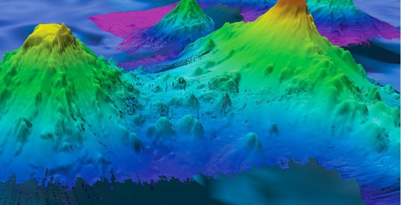
Just as mountains dominate the Earth’s surface, seamounts also rise above the ocean floor. Knowledge of the global distribution of these submerged volcanoes is still incomplete as just under a quarter of the ocean floor has been mapped. But there is another approach to providing information about these landforms. Using data from high-resolution radar satellites, researchers have mapped 19 325 new seamounts, expanding the previous catalogue of 24 643. This new and updated mapping has been published in Earth and Space Science.
Detecting seamounts from space
According to the study’s lead author David Sandwell, data from the European Space Agency’s (ESA) CryoSat-2 and the French and Indian space agencies’ Saral satellites can now detect mounts as low as 1,100 metres high, close to the 1,000-metre height limit that defines a seamount.
The first satellite-based survey was conducted in 2011. Led by David Sandwell, a marine geophysicist at the Scripps Institution of Oceanography, it was funded by the Navy and the National Geospatial-Intelligence Agency(NGA) following nuclear submarine collisions with uncharted seamounts. The research team identified 700 shallow mountains that were considered to be real hazards to navigation.
Satellites are a valuable resource for covering the breadth of our planet and for delivering data that are difficult to collect in situ during expeditions. The latest SWOT (surface water and ocean topography) satellite, one of the most powerful, can measure the height of a water surface to within a few centimetres. These radar satellites can detect seamounts, looking for changes in the topography above these formations, attracting water by gravity.
Seamounts and climate change
John Lowell, chief hydrographer at the National Geospatial-Intelligence Agency, which leads the US military’s satellite mapping efforts, says a better understanding of the shape of the seafloor will help prepare for climate change.
Currents carry heat from the equator to the poles, where the water cools and gains density until it plunges to the depths, taking carbon dioxide with it. These movements created by deep ocean water rising towards the surface have long been a mystery, in the authors’ words. The ‘upwelling’ was once thought to occur uniformly across the ocean, driven by turbulent waves at the boundaries between deep ocean layers of different densities.
Based on this new mapping, the researchers believe that this upwelling could be concentrated on seamounts and ridges. In practical terms, when ocean currents wrap around these submerged blocks, they create “wake vortices” that provide the energy needed to raise the cold water, explains Jonathan Gula, a physical oceanographer at the University of Western Brittany.
Seamounts as a biodiversity reserve
These mountains also host rare earth minerals, making them commercial targets for deep-sea miners. Their size and distribution contain clues about plate tectonics and the formation and solidification of magmas.
To biologists, the steep slopes of seamounts are like crowded, noisy skyscrapers for corals and other marine life. In an article in Science, Amy Baco-Taylor, a deep-sea biologist at Florida State University, explains: “They are oases for biodiversity and biomass. But the question remains: are they home to genetically distinct species, as on remote islands?
Knowledge of the morphology and distribution of seamounts will also strengthen efforts to protect biodiversity in international waters and could be used in a new treaty on marine protection.
Source : Gevorgian, J., Sandwell, D. T., Yu, Y., Kim, S.-S., & Wessel, P. (2023). Global distribution and morphology of small seamounts. Earth and Space Science, 10, e2022EA002331. https://doi.org/10.1029/2022EA002331