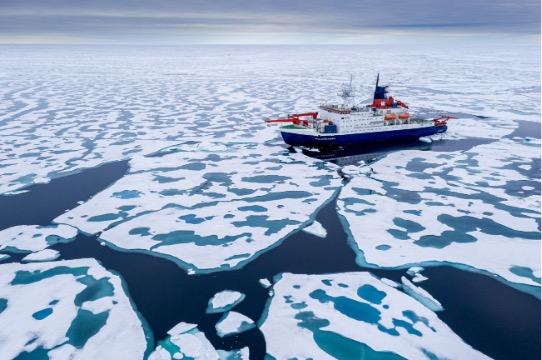
Sailing safely in the Arctic: The ACCIBERG project at the heart of innovations

21/03/2024

5 minutes

Pour tout le monde

oceans and technology

The ACCIBERG project is positioned as a concrete response to the risks linked to the presence of icebergs in Arctic waters, a crucial issue for navigation and marine ecology. By developing precise forecasting services thanks to the collaboration of several European institutions, the objective is to secure maritime routes and maintain economic activities. This project illustrates the importance of technological innovation in adapting to climate change and protecting vulnerable marine environments.

By Laurie Henry

A collaborative project to respond to Arctic challenges

Navigation in Arctic waters presents a major challenge due to extreme and changing conditions. Icebergs and sea ice in particular pose dangerous obstacles to ships, increasing the risk of accidents that can have disastrous consequences for both human life and the Arctic’s fragile marine environment.

In this context and that of climate change, access to precise informations on the position and movement of icebergs becomes crucial for planning safe routes and avoiding collisions.

Map showing the Northern Sea Route, the Northwest Passage and the Transpolar Sea Route.  © The Arctic Institute

Funded by the European Union under the Horizon Europe programme, the ACCIBERG project is a collaborative initiative led by Mercator Ocean International and other partners such as Stiftelsen Nansen Senter For Miljoog Fjernmaling(NERSC), Meteorologisk Institutt (METNO) , and the European Center For Medium-Range Weather Forecasts(ECMWF).

ACCIBERG aims to improve the quality of Arctic forecasts by developing services for predicting the trajectories of icebergs and sea ice. The solutions designed are based on advanced remote sensing and modeling technologies.

These forecasts promise to be a valuable tool for different stakeholders. Indeed, the information provided by ACCIBERG could benefit not only commercial vessel operators, such as cruise lines and fishing companies operating in the region, but also local communities dependent on the sea for their livelihood and research. scientist. By improving the safety of Arctic shipping, ACCIBERG plays a vital role in protecting Arctic marine ecosystems and supporting sustainable economic activities in a strategically important but particularly vulnerable region.

Technologies and methodologies

At the heart of ACCIBERG is the advanced exploitation of satellite remote sensing. Using images and data captured from space, ACCIBERG is able to detect icebergs with unrivaled accuracy, even in conditions where visibility is reduced by weather or time of year.

This capacity is enhanced by the development and application of new algorithms capable of analyzing raw satellite data. Unlike higher-level processed data products, the use of raw data allows greater flexibility and precision in interpreting sea ice and iceberg characteristics.

Concept of building ACCIBERG data and processing it for iceberg and sea ice forecasts. Arrows symbolize data flow, rectangles are software and blue clouds are cloud services, both developed in within ACCIBERG. © Mercator Ocean

In parallel, ACCIBERG relies on advanced numerical modeling models to simulate the dynamics of sea ice and the movement of icebergs. These models integrate oceanographic, atmospheric and cryospheric data to provide consistent forecasts at multiple temporal scales, ranging from days to months. Data assimilation, a technique that combines observations and models to improve forecast accuracy, plays a crucial role here. By continually adjusting models based on actual observations, ACCIBERG manages to significantly reduce forecast uncertainty.

These technological advances are complemented by the use of cloud computing, which provides the computing power needed to process large data sets and make forecasts accessible to end users in real time. Additionally, these improvements in sea ice and iceberg forecasting have the potential to enrich weather and ocean forecasts, contributing to a better overall understanding of Arctic environmental systems.

Towards safer circulation in the Arctic

Maritime security in Arctic waters is at the heart of the ACCIBERG project, which tackles head-on the risks posed by icebergs and sea ice. To achieve this objective, ACCIBERG has planned a series of demonstrations for the summer of 2024, a crucial step to validate the effectiveness of its forecasting services. These demonstrations will offer navigators and maritime professionals the opportunity to test the forecasts generated by the project in real conditions. The idea is to provide end users, such as ship captains, route planners and fleet operators, with accurate and reliable tools to anticipate the presence of icebergs on their journeys. By simulating navigation scenarios based on ACCIBERG forecasts, users will be able to evaluate the effectiveness of these tools in reducing risks and improving maritime safety.

Furthermore, ACCIBERG is also committed to improving existing systems. This involves an approach of increased accessibility and reliability of the information provided. By integrating uncertainty estimates into its forecasts, ACCIBERG allows users to better understand and assess the risks associated with their navigation decisions. This innovative approach, which consists of quantifying and communicating forecast uncertainty, represents a significant advance in the field of environmental forecasting. It helps decision-makers operate in a complex and changing environment, providing them with crucial information for risk management.

By equipping the maritime community with advanced tools to safely navigate one of the most demanding regions on the planet, this new ACCIBERG project aims to strengthen the resilience of maritime activities in the Arctic.

Read more

you might be interested in these events...... see everything