While the discovery and exploration of space seems to monopolize attention, an equally ambitious quest is taking place in the oceans of our planet. The Seabed 2030 project, in collaboration with various institutions such as the GEOMAR Helmholtz Centre and the Schmidt Ocean Institute, aims to fully map the seabed by 2030 and particularly highlight seamounts, a true oasis of life. This titanic challenge reveals not only the importance of bathymetric data but also the technological innovations that could transform our understanding of the oceans.
By Laurie Henry
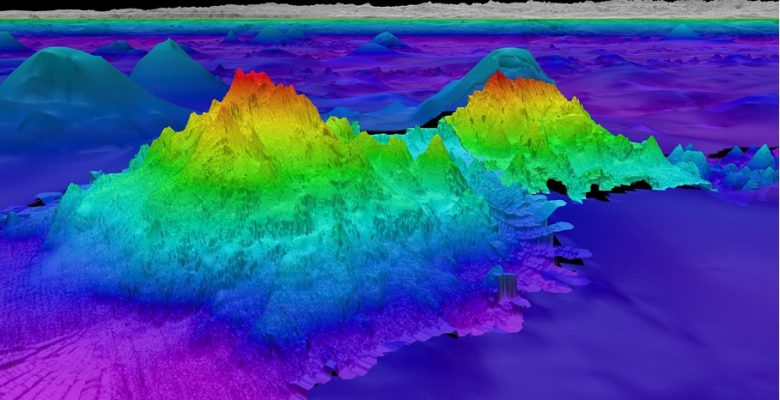
Cover photo: The largest of the four seamounts recently discovered by the Schmidt Ocean Institute’s R/V Falkor © Schmidt Ocean Institute, CC BY-NC-SA 4.0
Exploration of seamounts, a key to abyssal mapping
Seamounts are impressive geological formations that emerge from the ocean floor without reaching the water surface. These massive structures, often of volcanic origin, are crucial elements of ocean topography. Recent discoveries by the Schmidt Ocean Institute in areas such as the Salas y Gómez and Nazca Ridges in the Southeast Pacific have highlighted their significant ecological and geophysical role. These mountains strongly influence marine currents by modifying ocean flows, which can affect the regional and even global climate. Concretely, the way in which they modify local currents leads to the formation of areas of upwelling of cold water rich in essential nutrients for marine life.
The exploration of these underwater mountains also reveals exceptional biodiversity. Due to their isolation and specific environment, these seamounts are often home to endemic species that are found nowhere else on the planet. These ecosystems are in fact becoming biodiversity hotspots.
“It is therefore crucial to be able to map our seabed! »
As T. Hornyak explains in an EOS article, GEBCO (general bathymetric map of the oceans) and the Nippon Fondation(Japanese non-profit organization which channels the profits from motorboat racing towards philanthropic causes, editor’s note) have created Seabed 2030 in 2017. The aim was to use ocean mapping to support the United Nations Sustainable Development Goal 14, namely to “conserve and sustainably use the oceans, seas and marine resources for sustainable development “. At the time, only 6% of the seabed had been mapped with modern standards, according to the project.
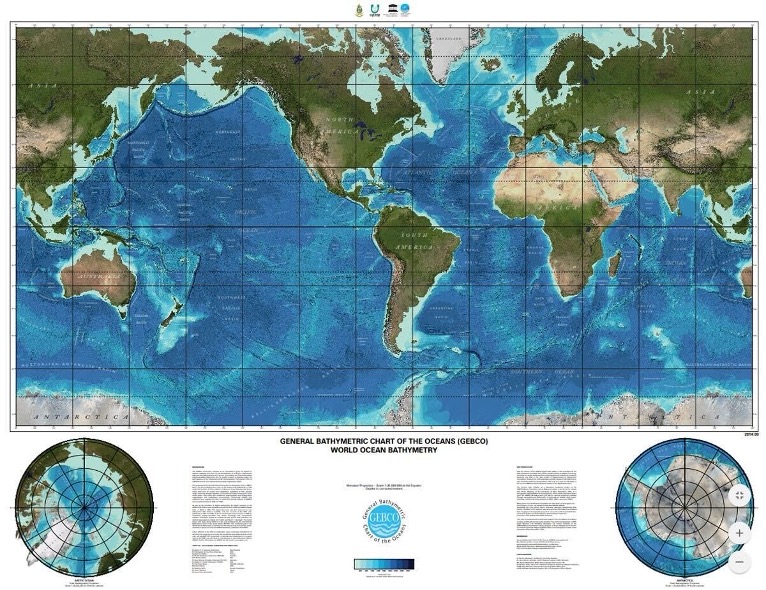
The GEBCO World Map shows the known bathymetry of the world’s seabed as a color shaded relief map. Images are based on the 2022 version of the GEBCO World Grid. © GEOMAR
All Seabed 2030 data is uploaded to the open access GEBCO seabed grid. The grid shows that 24.9% have been mapped to the Seabed 2030 resolution, leaving approximately 75% to be achieved over the next 6 years if the project objective is to be achieved.
Advanced technologies and methodologies needed for deep-sea mapping
Acquiring precise data on the ocean depths represents a real technical and logistical challenge, exacerbated by the immensity and complexity of the seabed. Echo sounders, traditionally used by ships, project sound waves towards the ocean floor and measure the time it takes for these waves to return to estimate the depth of the water. Although this method provides high resolution information, it is limited by the range of vessels and the difficulty of accessing certain remote or too deep areas. In response to these limitations, more advanced technologies have been developed to complement and extend the reach of traditional mapping.
Among these technologies, satellite altimetry and unmanned hydrographic drones are particularly promising. Satellite altimetry, for example, measures sea surface anomalies that can indicate variations in underwater relief. Although this method offers less fine resolution than that of echo sounders, it nevertheless allows large areas to be covered quickly, which is crucial for large, unexplored spaces.
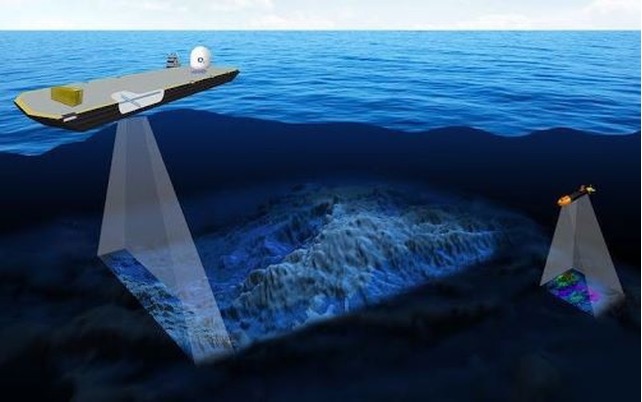
Detection of underwater reliefs. © Seabed 2030
On the other hand, hydrographic drones such as those promoted by the Seabed 2030 project in collaboration with institutions like GEOMAR, can navigate autonomously over long distances, up to 7000m deep. They collect multibeam sonar data that maps the ocean floor in detail at a much lower operational cost than manned ships. Still, it’s a massive undertaking given challenges such as permanent ice cover near the poles and the fact that about half of the world’s ocean is deeper than 3,200 meters.
Other experts hope new forms of artificial intelligence will speed up the mapping mission. In addition to surface and underwater exploration vessels, researchers at the Japan Agency for Marine and Earth Science and Technology (JAMSTEC) are deploying deep learning techniques to improve the resolution of existing topographic data.
The approach using convolutional neural networks* is “surprisingly effective and can be used as a complementary method to direct depth detection,” explains JAMSTEC data scientist Eiichi Kikawa in the EOS article.
International collaborations essential to discovering the seabed
The Seabed 2030 project, through its scale and ambitions, embodies unprecedented international cooperation in the field of marine research. The collaboration agreement between the GEOMAR Helmholtz Center for Ocean Research Kiel and the Seabed 2030 project, formalized by a memorandum of understanding, is a perfect example of this dynamic of cooperation.
Additionally, crowdsourcing and the use of open source data are essential for this project. It draws on data donations from multiple sources: scientists and philanthropists, offshore survey companies, and operators of fishing, cruise, and cargo ships.
Thus, in November 2023, the Seabed 2030 project revealed the receipt of a significant donation including data covering 8,000 square kilometers of remote and inaccessible regions. These high-resolution bathymetric data, offered by ARGANS, a British company specializing in remote sensing, were obtained using satellite observations. In a similar move, the Japanese Coast Guard helped enrich the GEBCO archives with a comprehensive set of bathymetric data encompassing the regions around Japan and Antarctica.
This collaboration is also part of a broader framework of ocean governance and marine conservation. By openly sharing collected data with the global community, the Seabed 2030 project and GEOMAR not only strengthen scientific research, but also facilitate the establishment of marine protected areas and marine spatial planning. These actions are vital for the protection of marine biodiversity and to ensure the sustainability of maritime resources.
They provide a solid basis for environmental and sustainable development policies globally. Indeed, the success of Seabed 2030 could transform the way we manage and protect our oceans, making these efforts crucial to the ecological future of the planet.
Source : T. Hornyak, “New seafloor map only 25% done, with 6 years to go”, Eos, 105, 2024
* Convolutional neural networks (CNN) are deep learning models structured in layers to process data arranged in a grid, such as images. They work by applying filters that recognize and analyze visual patterns to understand and classify images.