How the PACE satellite will transform our understanding of climate and oceans

15/02/2024

4 minutes

Pour tout le monde

oceans and technology

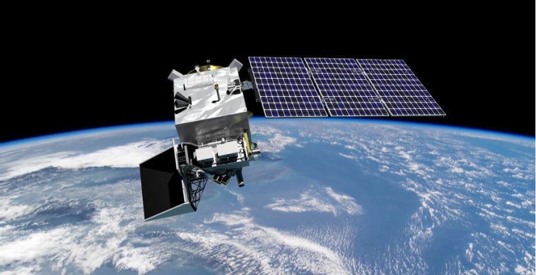
In a context where environmental challenges require precise and innovative scientific responses, the PACE (Plankton, Aerosol, Cloud, ocean Ecosystem) satellite launched by NASA represents a significant step forward. It aims to provide unprecedented data on the interactions between the oceans, the atmosphere and terrestrial ecosystems, with a view to understanding the impacts of climate change and improving the management of natural resources. The data will be used to formulate appropriate strategies for tackling global environmental challenges, complementing the SWOT satellite, to be launched in 2023.

by Laurie Henry

A successfull launch

The PACE satellite is a revolutionary tool for observing our planet. Equipped with advanced technologies, it is designed to analyse the complex interactions between the oceans, the atmosphere and terrestrial ecosystems with unequalled precision. Its ability to monitor fine particles, plankton and cloud characteristics opens up new perspectives for climate science.

It was launched at 1:33 am Eastern time on Thursday 8 February 2024 aboard a SpaceX Falcon 9 rocket from the Space Station in Cape Canaveral, Florida. The launch, initially scheduled for Tuesday morning, was delayed twice due to strong winds, but weather conditions were finally more than 95% favourable for the launch on Thursday morning. The rocket’s booster successfully landed on Earth around 10 minutes after launch, and just over thirty minutes after lift-off, the team confirmed that the spacecraft’s solar panels had deployed and that it was receiving power.


PACE satellite’s equipments © NASA

The many facets of the PACE mission

Monitoring the oceans

PACE will enable us to study marine biodiversity in detail, focusing on plankton, an essential component of the ocean food chain and a key indicator of the health of marine ecosystems. By monitoring the variations and distribution of plankton, PACE will provide vital clues about the health of the oceans and their ability to absorb CO2 from the atmosphere.

Comprising a rotating telescope, thermal radiators, a half-angle mirror and solar calibration mechanisms, the optical spectrometer known as the Ocean Color Instrument (OCI) is, according to NASA, its “most advanced colour sensor ever created”. While previous ocean sensors only detected a handful of colours, the OCI is hyperspectral and can observe more than 100 different wavelengths.

In practical terms, this will enable scientists to identify phytoplankton in the ocean by species from space for the first time, as ocean colour is determined by the interaction of sunlight with substances such as chlorophyll found in most types of phytoplankton. This in-depth knowledge will enable scientists to model future climate change with greater precision, providing a solid basis for political decisions and conservation strategies.

Fighting air pollution

The quality of the air we breathe has a direct and significant impact on our health, with consequences ranging from respiratory illnesses to more serious effects on the cardiovascular system. In this context, the PACE satellite will play a key role in providing detailed data on atmospheric aerosols, the fine suspended particles that can originate from natural sources such as volcanic eruptions or anthropogenic sources such as the combustion of fossil fuels, as well as megafires.

By mapping the distribution and analysing the chemical composition of these particles using HARP 2, its polarimeter, PACE offers a nuanced understanding of their dynamics and their interaction with climate systems and human health. The satellite also carries SPEXone, a spectro-polarimeter that will analyse the light reflected by the Earth’s atmosphere.

This information will enable researchers and decision-makers to target pollution sources more effectively, implement stricter air quality policies and develop appropriate mitigation strategies, thereby helping to protect public health and combat global warming.

Origins of aerosols © Earth Observatory NASA 

What is the link with the SWOT satellite ?

SWOT, launched in December 2022, focuses on mapping the height of water over more than 90% of the Earth’s surface, including oceans, lakes, rivers and reservoirs. SWOT and PACE illustrate NASA’s integrated approach to studying the Earth, where each mission contributes complementary pieces to a complex puzzle. In other words, the complementary nature of SWOT and PACE lies in their ability to provide a multidimensional image of the Earth.

While SWOT precisely maps the distribution and variations in water height over the planet, providing essential data on the dynamics of fresh and salt water and the impacts of climate change, PACE enriches this image by examining the chemical and biological composition of the oceans through the study of phytoplankton, aerosols and clouds. This synergy enables us to understand not only how water is distributed and moves around the Earth, but also how it interacts with marine life and the atmosphere, influencing the global climate.

Together, SWOT and PACE offer a comprehensive perspective on the water cycle, biogeochemical cycles and climate processes, facilitating more informed management of natural resources and better preparation for future environmental challenges.

More informations

you might be interested in these events...... see everything