[vc_row css_animation=”” row_type=”row” use_row_as_full_screen_section=”no” type=”full_width” angled_section=”no” text_align=”left” background_image_as_pattern=”without_pattern”][vc_column][vc_column_text]By Laurie Henry
Today, weather forecasts are part of our daily lives. They come from numerical simulations carried out with atmospheric models. What about the ocean, an essential component of the climate system: are there ocean models, ocean forecasts, and if so for what use?
Increasingly accurate ocean models
It was in 1967 that Kirk Bryan and Michael Cox developed at the GFDL (Geophysical Fluid Dynamics Laboratory, laboratory of the American Agency for Oceanic and Atmospheric Observation, NOAA) the first three-dimensional model of the ocean, called “Bryan- Cox code”, and since then widely distributed in institutes involved in ocean and climate modelling.
An ocean model is a complex computer program simulating the physical state and dynamic properties of the oceans. Concretely, this computer program numerically solves equations that describe the movements of the geophysical fluid that is the world ocean, stuck to a rotating sphere, the Earth, and bordered by continental borders. Starting from fundamental principles, such as the conservation of energy or momentum, the equations derived from fluid dynamics characterize the evolution over time of physical quantities, such as temperature, salinity, current speed.
A mesh is defined on the globe, on which these equations are solved, with a precision all the greater as the mesh is fine. The resolution of the model can vary from 100 km for climate models to a few km for a local study. It’s also necessary to define the initial state of the ocean and the conditions at the boundary of the oceans with the atmosphere, and at the bottom of the oceans. Indeed, the air-sea interaction focuses on the exchange of quantities, such as heat or humidity, across the surface of the ocean.
Once all these ingredients have been combined, the oceanographers launch the execution of the program which calculates the evolution over time of the various physical quantities. The program is run on supercomputers and requires thousands of computing hours. Each model knows many updates and innovations resulting from studies carried out in the various research institutes in order to best represent the state of the oceans.

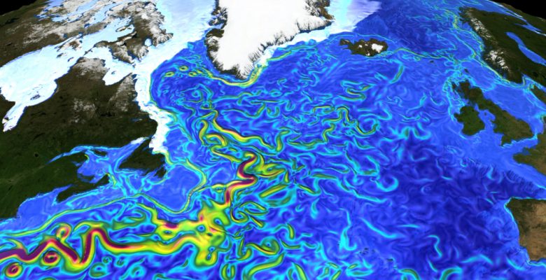
Surface currents modeled at 8 km resolution. © CEMS

Surface salinity modeled at 8 km resolution. © CEMS
Modeling to build a plural image of the ocean
Like weather models, ocean models are used to make ocean forecasts as part of operational oceanography and are integrated into climate models to make IPCC climate projections (Intergovernmental Panel on Climate Change).
Operational oceanography is defined, in an article establishing the state of knowledge, as “the set of activities for the generation of products and services providing exploitable information on the marine and coastal environment, designed to meet societal and scientists “.
The European Ocean Monitoring Service (CMEMS), implemented by Mercartor Oceans in Toulouse, implements operational oceanography and provides ocean forecasts, which have become essential for a wide range of maritime activities. Forecasts can be short-term, to ensure safety and support tactical decisions, or longer-term, to support planning and resilience activities, such as sustainable fishing.
In addition, CMEMS issues warnings on coastal flooding, ice and storm damage, harmful algal blooms and contaminants, etc. It establishes maps viewable online, the optimal routes for ships, the forecast of seasonal or annual primary productivity, ocean currents, ocean climate variability, etc. Final products and forecasts must be distributed quickly to industrial users, government agencies and regulatory authorities.
Note also that a wide variety of operational models are currently used in European seas, based on different ocean models, with a disparate range of spatial and temporal scales and various data sources. A recent study lists these models, identifying their strengths and weaknesses, as well as their uses.
Last point, digital ocean modeling is one of the key tools to better understand the distribution of marine litter, especially microplastics. Over the past decade, a series of numerical simulations, as summarized in a 2017 study, have been built, specifically targeting floating marine litter, based on ocean models of varying complexity. Some of these models include the effects of currents, waves and wind as well as a range of processes that impact how particles interact with ocean currents, including fragmentation and degradation. Moreover, a 2021 study by Maes et al. analyzes the fate of floating plastic pollution discharged along the coast using these models.
Models for international cooperation
IPCC climate projections are made with climate models, made up of a combination of models: atmosphere, ocean, continental surface, sea ice, etc. They relate to the long term and provide different scenarios for the increase in greenhouse gases from the pre-industrial period to the end of the 21st century.
The rapid increase in greenhouse gases in the atmosphere is causing heat to build up within the climate system. It’s the ocean that absorbs more than 90% of the excess heat accumulated in the climate system. It has a regulating role because it heats up less quickly than the atmosphere, but this quantity of heat accumulated today has consequences on the evolution of sea level, the increase in air temperatures, the melting of the ice…
Ocean models therefore play an essential role in climate models to best predict the impacts of climate change.[/vc_column_text][/vc_column][/vc_row]