Ocean forecasting now guides a multitude of decisions at sea, from rescue operations to fishing. On a global scale, a discreet infrastructure combines satellites, supercomputers and sensors to anticipate ocean dynamics. We take a closer look at a strategic system with numerous scientific and geopolitical ramifications.
by Laurie Henry
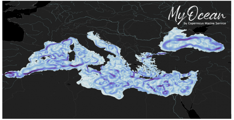
Cover photo: Visualisation of surface currents in the Mediterranean and Black Sea forecasting systems provided by Copernicus Marine Service. © M. CIrano et al., 2025
Ocean forecasting is no longer the sole preserve of meteorologists and the military. It has become a strategic tool in a world where the sea is at the centre of issues relating to security, navigation, resource management and climate resilience. Anticipating currents, temperatures and sea conditions a few days in advance is now essential for governments and economic players alike, from shipping companies to coastal fishermen.
This growing need for reliable, targeted information has led to the rise of operational ocean forecasting services on a global scale. A collective study involving no fewer than 30 researchers provides an overview of these services. Published in June 2025 in the journal State Planet, it offers a detailed panorama of current ocean forecasting capabilities.
Operational science at the service of marine forecasting
Operational ocean forecasting is based on a demanding scientific foundation: modelling physical, chemical and biological processes on the scale of the global ocean and its coastal margins. To achieve this, digital systems integrate satellite observations, in situ data (buoys, gliders, Argo sensors) and complex ocean circulation models, such as NEMO, HYCOMand POM. These systems make it possible to predict changes in currents, temperature, salinity and waves, as well as biogeochemical parameters such as oxygen and chlorophyll.
The study shows that more than 150 ocean forecasting systems are currently listed in the OceanPrediction atlas, a global database. They cover eight major regions of the world, from the Western Pacific to the Arctic, and include global and regional services. These systems provide 5- to 10-day forecasts, with resolutions ranging from 25 km for global models to less than 1 km for coastal systems.
Home page from Ocean Prediction website © M. Cirano et al., 2025While almost all models incorporate data assimilation (a statistical method for bringing the model closer to reality, editor’s note), two systems use ensemble techniques simulating multiple scenarios to estimate forecast uncertainty. Some variables, such as currents and surface temperature, are simulated with a high degree of accuracy. Other variables, such as biogeochemical variables, remain more difficult to predict with great precision. However, these forecasts are essential for anticipating extreme events (waves, cyclones, storm surges) or tracking climate trends such as marine heatwaves.
Regional systems adapted to contrasting ocean environments
Ocean forecasting in each region of the globe presents its own challenges. In the seas bordering East Asia, ocean variability is dominated by typhoons, upwellings and interactions with large rivers. The JCOPE model, operated by JAMSTEC (Japan Agency for Marine-Earth Science and Technology) in Japan, is capable of representing eddy currents in this area with a resolution of approximately 10 km. It also includes the effects of river inflows, which are essential for simulating salinity near the coast.
In China, the MaCOM model, developed by the National Centre for Marine Environmental Forecasting, is based on strict physical conservation principles, strictly adhering to the laws of physics to ensure that water, heat and salt do not disappear artificially. It can operate from the global level (10 km) to the coastal scale (100 m), providing useful forecasts for fishing, pollution monitoring and ice pack tracking activities.
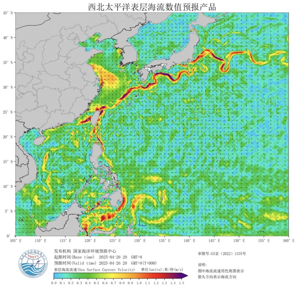
Surface currents derived from the MaCOM system. © M. Cirano et al., 2025
In the Indian Ocean, two regional models are often used: HYCOM and ROMS, with resolutions ranging from 9.2 to 2.3 km for coastal areas. These models predict winds, waves, tides, currents and temperature by combining satellite data and onboard sensors. Data assimilation, i.e. adjusting the model with real-time observations, uses methods such as Tendral SIS or LETKF. These techniques make it possible to correct the model by integrating satellite or sensor data, which greatly improves the accuracy of forecasts, particularly in the Indian Ocean where conditions change rapidly under the influence of the monsoon.
In less well-equipped regions, such as certain areas of Africa, regional forecasts still rely heavily on global models. Platforms such as MarCOSIO and MarCNoWA seek to strengthen local capacities by using tools such as the GCOAST model, which is capable of achieving a resolution of up to 50 metres in estuaries. GCOAST is a model developed by the German institute Hereon, which specialises in research on coastal and marine environments.
From forecasting to strategic and civil applications
The importance of ocean forecasting extends beyond scientific research. It has become an operational infrastructure serving many sectors. Defence services use this data to plan submarine trajectories, avoid areas of turbulence and optimise ship positioning. For example, the Real-Time Ocean Forecasting System (RTOFS) of the NOAA (United States) integrates the HYCOM model on a 9 km grid, with daily updates. It is used in military contexts but also for storm forecasting.
In coastal countries such as Mozambique and South Africa, systems such as FEWS-INAM and SOMISANA provide 3- to 5-day forecasts, including swells, storm surges and currents, for fishermen, port authorities and risk managers. These models incorporate data from the Copernicus Marine Service, refining it locally.
À Chypre, le système CYCOFOS produit des prévisions côtières pour surveiller les pollutions ou prévenir les accidents en mer. Ce type de service est souvent couplé avec des outils de traçage des nappes d’hydrocarbures comme l’outil OpenDrift utilisé en Afrique du Sud.
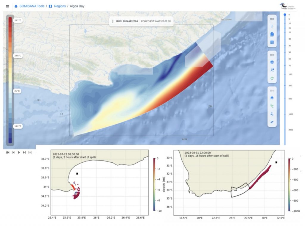
Portal for the bay forecasting system developed by SOMISANA in South Africa, integrating water table monitoring with OpenDrift. © M. Cirano et al., 2025
In the field of climate science, certain models enable the monitoring of high-frequency phenomena such as marine heatwaves, which affect ecosystems and fisheries. Biogeochemical modelling, although still under development, is playing an increasingly important role. For example, the PISCES model (used by Mercator Ocean) predicts oxygenation, nutrients and biological productivity. Marine forecasting has thus become a critical public service, integrated into risk planning, environmental monitoring and maritime safety management.
Towards more accurate, integrated and open forecasting
The evolution of ocean forecasting services now involves three priorities: increasing model resolution, improving multi-source integration, and enhancing data accessibility.
The rise of model-data coupling is a major lever. More and more systems are integrating real-time observations via satellites, autonomous sensors, and even marine drones. Systems such as OceanMAPS in Australia and Bluelink are improving their real-time forecasts in dynamic areas by comparing model results with observed data using a method called ensemble Kalman filtering, which uses multiple simulations to correct and refine forecasts.
Another key challenge for the future is data openness. Nearly half of the systems listed in the OceanPrediction atlas have not yet been operationally validated, and some only make their data available on request. This situation hinders local innovation. The challenge is therefore to standardise access via open platforms such as the Copernicus Marine Data Store or the INCOIS portal, which allow models, products and historical data to be downloaded.
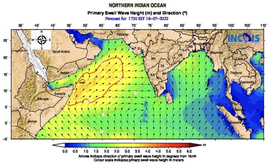
Example of wave forecast produced by INCOIS. © M. Cirano et al., 2025
Finally, local resolution is a key factor in forecast accuracy. In densely populated coastal areas, such as the Strait of Gibraltar, the Gulf of Mexico and the Korean coast, some systems achieve accuracy of 300 m to 1 km, incorporating the effects of tides, local winds and complex bathymetry. This modelling scale paves the way for forecasts that can be used at the level of ports or areas of ecological importance. Ultimately, the ambition is to build an integrated, continuous and distributed forecast capable of combining weather, ocean and coastal environment data to respond to the growing complexity of maritime uses.
Source : Cirano, M., et al., “A description of existing operational ocean forecasting services around the globe, in: Ocean prediction: present status and state of the art (OPSR)”, edited by: Álvarez Fanjul, E., Ciliberti, S. A., Pearlman, J., Wilmer-Becker, K., and Behera, S., Copernicus Publications, State Planet, 5-opsr, 5