While the 33rd French campaign in its name is underway, the international PIRATA program enables the uninterrupted collection of ocean and atmospheric data in a strategic tropical Atlantic Ocean. Indeed, air-sea interactions are strong and often unpredictable, sometimes with disastrous consequences for local populations. Long-term monitoring is the key to better forecasting weather and ocean changes and extreme events.
An international network for operational monitoring
Air-sea interactions have a significant impact on short-term meteorological variability, and on longer-term climate variability. They are essential to know to better predict weather and ocean changes and extreme events. In the tropical Atlantic Ocean in particular, these interactions are strong and can have sometimes catastrophic consequences on the environment as well as on populations: droughts, floods, marine heat waves, violent tropical storms, hurricanes, presence or absence of marine resources etc.
This is why in 1997, the PIRATA operational oceanography program was born – for “Prediction and Research Moored Array in the Tropical Atlantic”, or “fixed network for forecasting and research in the tropical Atlantic”. Placed under the aegis of the international CLIVAR program (Climate Variability and predictability) and carried out within the framework of multinational cooperation (France, Brazil and the USA), PIRATA is an observatory entirely dedicated to the study of ocean-atmosphere interactions in the Tropical Atlantic, and their role in regional climate variability at seasonal, interannual or decadal scales.
Thanks to PIRATA, a multinational network of meteo-ocean buoys has been set up, serving as the backbone for the observation of the tropical Atlantic. These buoys are replaced every year, and three current meter moorings, replaced every two years, complete the network along the equator. The collection of a multitude of meteo-ocean data made on an ongoing basis makes it possible to deepen scientific knowledge on the link between the ocean and climatic variability in a key region for the thermal regulation of the planet, both its role in the redistribution of heat from the equator to the poles is fundamental.
Scientific objectives and means
The PIRATA network has eighteen fixed moorings, six of which are maintained by France in the central and eastern part of the basin on the Gulf of Guinea side.
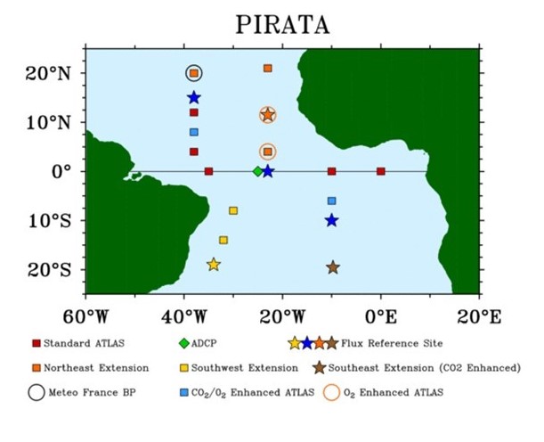
Location of PIRATA campaign buoys. © PIRATA-IRD
Each mooring is equipped with a buoy, allowing oceanic observations (temperature and salinity between the surface and 500m depth, surface current at certain sites) and meteorological (wind, relative humidity, air temperature, rainfall, incident radiation at the surface of the ocean), connected to the bottom of the ocean with a ballast of 2 to 3 tons. These data, acquired and transmitted daily by satellite, make it possible to follow and understand the evolution of the surface thermal structure, the transfers between the ocean and the atmosphere of heat and fresh water, the spatial and temporal variations of currents . CO2 exchanges between the ocean and the atmosphere are also estimated.
In addition, three current meter moorings are installed along the equator and submerged for two years, in order to allow continuous measurement of very high currents at the equator (in particular the equatorial undercurrent).
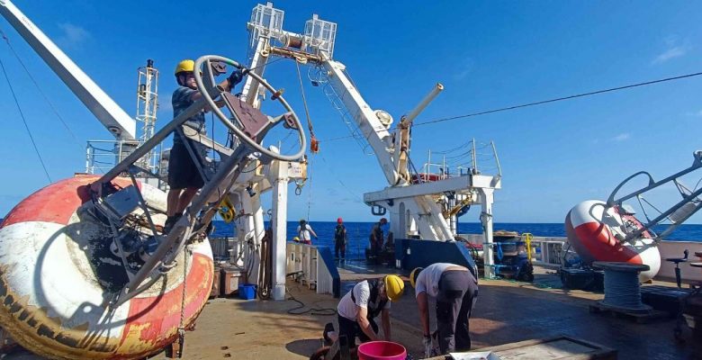
The maintenance of the PIRATA observatory requires the organization of one oceanographic campaign per year. Thus, 32 cruises have been carried out by France from 1997 to 2022, i.e. more than 800 days at sea. There are also 21 cruises for Brazil and 17 for the United States which only started in 2005. Each cruise PIRATA lasts about forty days, involving a multidisciplinary scientific team made up of researchers, engineers and technicians responsible for maintaining the network, and in particular replacing the moorings and changing the electronic sensors fitted to them.
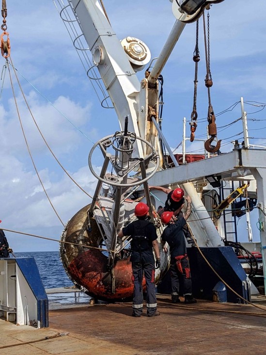
A PIRATA buoy under maintenance. © Margaux Brandon
In addition to these fixed measurements obtained thanks to the moorings, additional measurements are taken along the ship’s route. The production of hydrological profiles, the deployment of drifting buoys and autonomous ARGO profilers, the replacement of receivers dedicated to the monitoring of marine mammals previously banded, the taking of samples of seawater, algae (Sargassum), crustaceans present on the buoys or pieces of tuna (when caught) thus contribute to the global ocean observation system. Subsequent analyzes on the samples taken will provide valuable information on many physicochemical and biogeochemical parameters (dissolved oxygen, salinity, pH, nutrient salts, chlorophyll pigments, carbon parameters, mercury content, etc.).
International results for long-term perspectives
PIRATA very usefully supplements the data collected by satellites. It makes it possible to refine weather forecasts and adjust oceanic and even biological climate models developed in laboratories. This is how every year for the past 20 years, Mercator Ocean has provided daily forecast maps (current, temperature, salinity) in this region of the tropical Atlantic. These charts, which arrive directly on board the PIRATA cruises, are available from 2 a.m. GMT for three timeframes (the day’s analysis and forecasts for the next two days), and obtained using Mercator’s global digital daily forecast model with a resolution of the order of 8 km at the equator.
PIRATA is internationally recognized as a reference observatory for obtaining meteo-ocean measurements necessary for studies of climatic processes in the Tropical Atlantic. Eleven universities and international organizations have used PIRATA anchorages and expeditions to deploy scientific instruments and acquire particular measurements.
The PIRATA observation network has become a structuring network in the Tropical Atlantic for climate forecasting and research, particularly within the framework of European programs. PIRATA contributes to OceanSITES and is one of the major components of the Tropical Atlantic Observing System (TAOS). At the national level, PIRATA has been labeled a “national observatory” since 2001 and its labeling as a “Service National d’Observations -SNO-Océan-Atmosphere”, essentially supported by the IRD and Météo-France, has been renewed for the period 2020-2024.
The official PIRATA website : https://www.pmel.noaa.gov/gtmba/pmel-theme/atlantic-ocean-pirata
Link to our IMAGO article : https://oceansconnectes.org/imago-sonde-les-oceans/
Link to our article on moorings : https://oceansconnectes.org/reseau-observations-meteo-oceaniques-pirata/