By Laurie Henry
At the beginning of April, the global ocean surface temperature reached 21.1°C, the highest ocean surface temperature on record since 1980 and the start of satellite measurements. This sad record is the result of heat buildup in the oceans caused by climate change. Scientists warn of more marine heat waves and extreme weather events.
Why such a dramatic rise in temperatures?
As greenhouse gases accumulate in the atmosphere, oceans and continents are warming. Since the industrial era, more than 90% of the additional heat injected into our Earth system as a direct result of our greenhouse gas emissions has already been absorbed by the ocean.
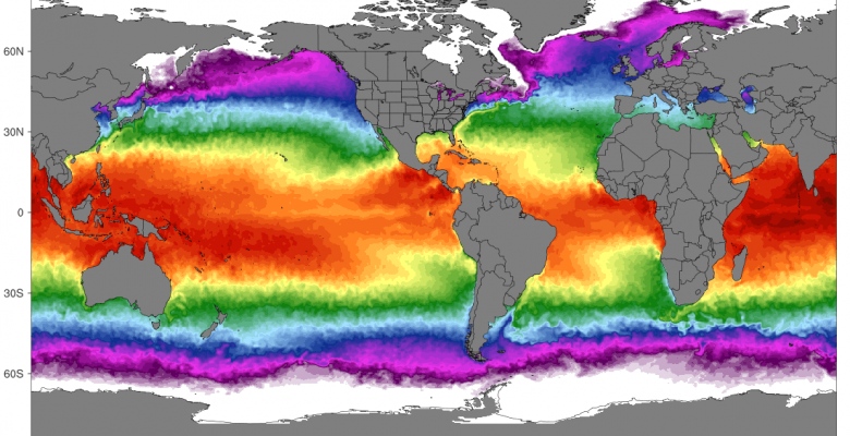
But the trends vary, particularly according to the La Niña and El Niño cycles in the Pacific Ocean, between Indonesia in the west where the waters exceed 30°C, and Peru where the surface waters are around 23-24°C. This temperature difference causes a pressure difference in the atmosphere which generates trade winds (winds coming from the east). Under normal conditions, these trade winds carry a very large amount of warm water from South America to Asia through a powerful ocean current called the Pacific jet stream. To rebalance the water column in the east, cold water rises from the depths along the American coast (through a process called upwelling). This ocean-atmosphere interaction makes the waters of the western Pacific warmer and the waters of South America even colder, and naturally maintains the system.
El Niño and La Niña are two opposing weather patterns that break these normal conditions and strongly impact oceanic and meteorological conditions, changing the position of the Pacific jet stream:
- During La Niña years, the Pacific trade winds blowing from east to west are much stronger. During La Niña years, the Pacific trade winds blowing from east to west are much stronger, pushing warm surface waters even further west and causing significant upwelling of cooler, deeper waters to the east.
- Conversely, during El Niño years, a westerly wind anomaly causes a decrease in the trade winds, causing warm surface waters to move from west to east. This will reduce the temperature difference between east and west, further reducing the trade winds and causing more warm water to move upwards. As it moves, this warm water will rise to the surface of the ocean and, as a result, the air temperature will increase by up to 3 or 4 degrees.
For April 2023, preliminary data from the National Oceanic and Atmospheric Administration (Noaa) showed a monthly average ocean surface temperature of 21.1°C, well above the previous record of 21°C set in 2016. Both records are also more than a degree above the 1982-2011 global average of 20.4°C in early spring, according to data from the University of Maine’s Climate Reanalyser.
This temperature increase is explained by both a weakening of a three-year old ‘La Niña‘ regime in the tropical Pacific, which had so far strongly contributed to reducing ocean surface temperatures and moderating the absorption of heat from the atmosphere into the ocean.
However, with excess heat due to global warming, the ocean has absorbed enough heat in the west at the subsurface (around 300 metres) to set up the conditions for a future El Niño. By the coming winter of 2023, if a westerly wind anomaly appears, scientists predict a shift to an El Niño regime, which will be accompanied by an increase in global ocean surface temperatures, and consequently in atmospheric temperatures. As Dr Mike McPhaden, a senior scientist at NOAA, points out in an article in the Guardian: “Now that it’s over [La Niña], we’re probably seeing the climate change signal coming in loud and clear.”
What are the risks for oceans and people?
A study dating from 2022 had already concluded that heat records were recorded punctually in the oceans in 2021.
Warmer ocean surface temperatures mean more marine heat waves, which is happening now and simultaneously across the world. The conditions leading to warming oceans are also causing a catastrophic increase in temperatures on the continents, which are warming far more than the oceans.
Professor Adam Scaife, head of long-range forecasting at the UK Met Office, told The Guardian earlier this year: “We know that with climate change the impacts of El Niño events are going to intensify, and you have to add that. to the effects of climate change itself, which continues to grow. You put those two things together, and we’ll probably see unprecedented heat waves in the next El Niño.”
Rising temperatures and increased marine and terrestrial heat waves have multiple consequences: melting of continental ice, rising sea levels, disruption of the hydrological cycle accompanied by extreme events (more violent and longer storms , intense and long-lasting droughts), or threats to marine life. And like a feedback loop, evaporation and drying of soils in turn increases the risk of heat waves and wildfires.
Monitoring the ever warmer oceans
But if the ocean is warming strongly at the surface, it is also warming at depth: measurements have shown a global average warming of +0.3°C between 0 and 700 meters depth, over the period 1875-2010 (Rhein et al ., IPCC 2013). The direct consequence is that of an ocean becoming more stratified, which inhibits mixing between the surface ocean layers and the deeper layers and makes the absorption of CO2 and oxygen less efficient.
This slow penetration of heat towards the great ocean depths implies a global warming stored in memory in the ocean for many decades, to increase and whose consequences for the marine environment will still be visible for a long time, even after the stabilization of gases. Greenhouse effect.
It is therefore imperative to continue and strengthen ocean observations to understand and apprehend the future climate, in particular using Argo floats. The new generation of floats currently in preparation should be able to dive deeper, up to 6000 meters deep instead of the current 2000 meters.
The objective is to have sufficient technological means to follow this climatic signal from the surface to the greatest depths over the long term and across the entire planet. These data are also a necessity for numerical weather and ocean models, which also need to refine their forecasts using data collected at sea.