In the heart of the Indian Ocean, the island of Madagascar is one of the territories most exposed to tropical cyclones. Each season, these phenomena trigger devastating coastal flooding, amplified by the interaction of sea flooding with river flooding. A study of Cyclone Batsirai, which ravaged the island in 2022, demonstrates the complexity of cyclones and the increased risks for vulnerable populations in this region.
by Laurie Henry
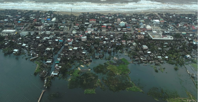
Cover photo: Aerial view of the Mananjary area after Cyclone Batsirai (6 February 2022). © WFP/Nejmeddine Halfaoui
In 2022, Cyclone Batsirai ravaged the east coast of Madagascar, causing dozens of deaths, thousands of displaced persons and considerable economic losses. A new study has examined this episode and reveals the largely underestimated phenomenon of composite flooding, caused by the interaction between sea flooding and river flooding. Although this threat is still not widely anticipated, it is now better modelled.
One of the most cyclone-prone territories in the world
Madagascar accounts for 14% of the world’s cyclones, or around nine per year. Of the 75 cyclones that crossed this region between 2002 and 2023, 40% directly affected Madagascar. The island is therefore subject to a much higher frequency of impacts than comparable areas such as the United States, where an average of two cyclones make landfall each year.
The territory’s vulnerability is exacerbated by its geographical location, mountainous terrain and high level of socio-economic insecurity. The country has a population of around 32 million, with a per capita GDP of only $529 in 2023 (source: IMF). While this poverty limits the capacity to prevent, prepare for and respond to these violent and rapid phenomena, coastal populations in particular are exposed without any real protection.
The trajectories of cyclones reaching Madagascar vary. Some skirt the east coast and then move south, while others cross the entire island to reach the Mozambique Channel. Mountainous areas also promote orographic rainfall (precipitation caused by the relief), exacerbating the already intense rainfall generated by cyclones. All this diversity naturally complicates the modelling of impacts.
Despite this exceptional exposure, Madagascar remains understudied by the international scientific community. Research there suffers from a glaring lack of reliable local data, observation networks and integrated high-resolution modelling. This shortcoming compromises the ability to anticipate extreme events and protect the most exposed areas and populations, particularly those on the coast.
Cyclone Batsirai reveals a complex phenomenon
Cyclone Batsirai, which struck Madagascar in early February 2022, brutally exposed the current limitations in our understanding of cyclone-related flooding. This category 4 cyclone, with winds reaching 230 km/h and a minimum pressure of 932 hPa, made landfall on 5 February in Mananjary. It caused extensive damage, with 123 deaths, more than 60,000 people displaced, 19,000 homes destroyed or damaged, 4,000 classrooms unusable and economic losses in the order of $190 million.
But beyond the figures, Batsirai highlighted the composite nature of the floods. According to researchers, the flooded areas were affected by a double mechanism: marine submersion linked to the storm (tide, swell, storm surge) and river flooding caused by extreme rainfall. In a single day, nearly 300 mm of rainfall fell in the Mananjary basin.
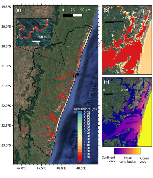
Flooding reproduced by the model during Cyclone Batsirai (a) across the entire Mananjary watershed, with the inset showing the fine-scale structures of the flooding. Panel (b) shows the extent of flooding in the town of Mananjary. Panel (c) shows the relative contribution of oceanic and continental factors to flooding in the same area. © Khan, M.J.U., et al. 2025
This type of combined or “composite” flooding has the particularity of exacerbating the effects: intense runoff prevents water from flowing naturally towards the sea, while the sea, itself at high tide, prevents rivers from draining. The phenomenon is therefore non-linear: not only do the two effects not add up, but they reinforce each other, trapping water on the coast and inland.
The southern part of the cyclone’s path, particularly Nosy-Varika, Manakara and Mananjary, was the most severely affected, with flooding extending up to 10 km inland in some cases. A detailed analysis of Cyclone Batsirai helps to explain why these areas were so severely affected.
A coupled model to decipher composite floods
Faced with the complexity of the floods observed in Madagascar, researchers have designed a novel numerical modelling system capable of simultaneously representing oceanic and continental dynamics. This system combines two complementary tools: the SCHISM-WWM model to simulate phenomena at sea, and the SFINCS model to model flows on land.
The SCHISM-WWM model (Semi-implicit Cross-scale Hydroscience Integrated System Model coupled with the Wave-Watch Model) is a hydrodynamic model that accurately reproduces swells, tides and storm surges, taking into account underwater topography and cyclonic winds. It is used to understand how the sea behaves during a cyclone. The SFINCS model (Super-Fast INundation of CoastS) is a flood and runoff model that simulates how rainwater, rivers and runoff flood land areas, based on terrain, land use and soil properties.
The two models are connected: the water levels simulated by SCHISM-WWM at sea are transmitted to SFINCS, which uses them as a starting point to calculate the extent of flooding on land. This coupling makes it possible to accurately reproduce the interaction between marine submersion and river flooding — an essential characteristic of composite floods.
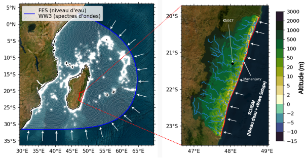
Configuration of coupled digital models, with the large-scale coupled ocean-wave digital model on the left and the fine-scale continental flooding model deployed on the Mananjary watershed on the right. The colour scale represents altitudes. © Khan, M.J.U., et al. 2025
Applied to the Mananjary basin, this high-resolution model (30 m) achieved an 83% concordance rate with satellite observations. The model shows that water can remain trapped in coastal plains, with slowed or reversed drainage, even after the swell has subsided. Until now, this phenomenon has been difficult to reproduce numerically, especially given the scarcity of field data.
Social and agricultural consequences still largely unforeseen
Beyond the physical mechanisms, composite floods in Madagascar have direct effects on populations and agricultural systems. The study reveals that 30% of the areas flooded by Cyclone Batsirai were agricultural land. This figure is particularly alarming for a country where agriculture is an essential source of income and food security.
The estimated loss to the agricultural sector amounts to €47 million, or approximately $53 million, equivalent to 1% of the national GDP. In the medium term, the consequences are also significant, with numerous crop losses, soil depletion, land salinisation, and in some cases crop abandonment or population displacement. All of these direct and indirect impacts are rarely included in traditional risk management tools.
After Cyclone Batsirai struck, there was massive population displacement, with more than 60,000 people displaced, often permanently, due to a lack of rehousing solutions. These climate-induced migrations add to existing pressures on urban areas and exacerbate precariousness.
The authors of this new scientific study on Cyclone Batsirai and its consequences for the island of Madagascar emphasise the importance of moving from a global risk assessment to a local assessment, incorporating specific social and economic factors. The proposed model can provide risk maps at the village or even household level, thereby supporting policy decisions on zoning, urbanisation and relocation. Ultimately, this type of approach could become an essential tool for integrating water risks into land use planning policies, particularly in view of the expected effects of climate change.
Source : Khan, M.J.U., Durand, F., Afroosa, M. et al. “Tropical cyclone induced compound flooding in Madagascar: a coupled modeling approach”. Nat Hazards (2025).